A Past Unravelled

• Information Hidden in the Veduta •

HU EN SK

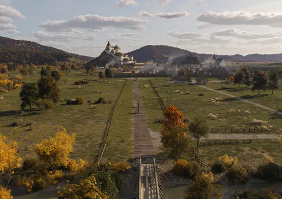
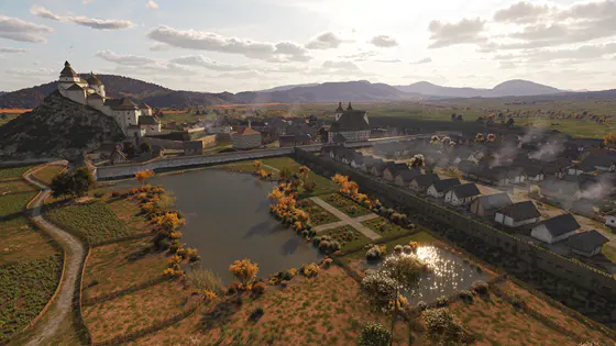
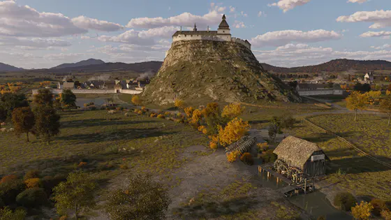
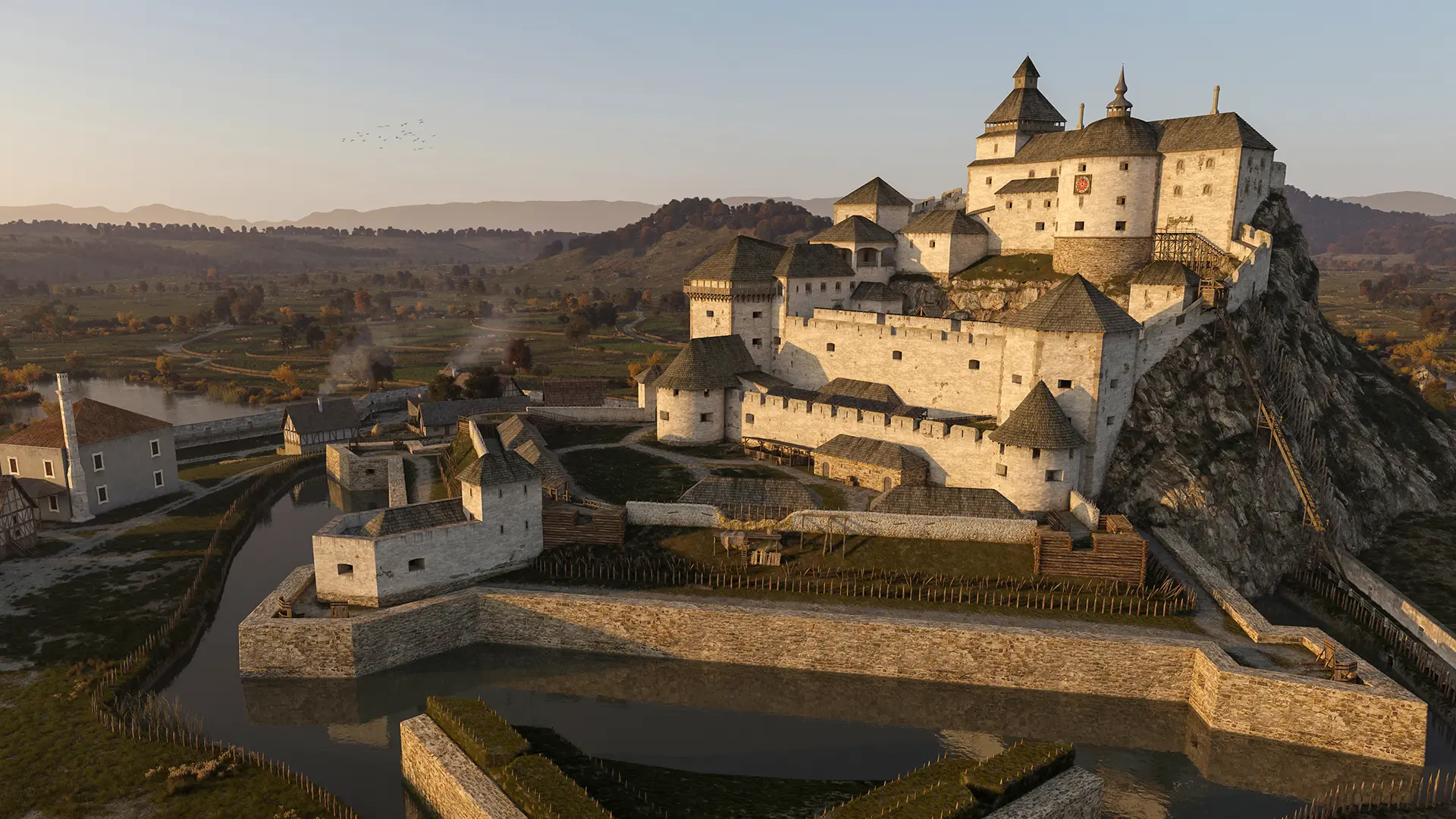
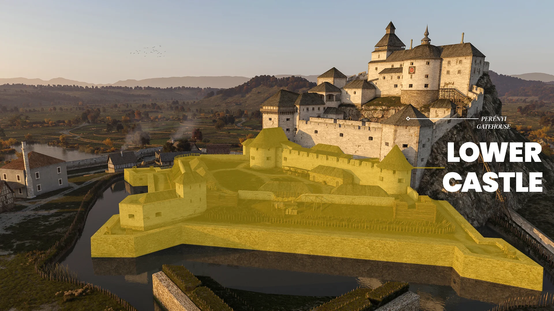
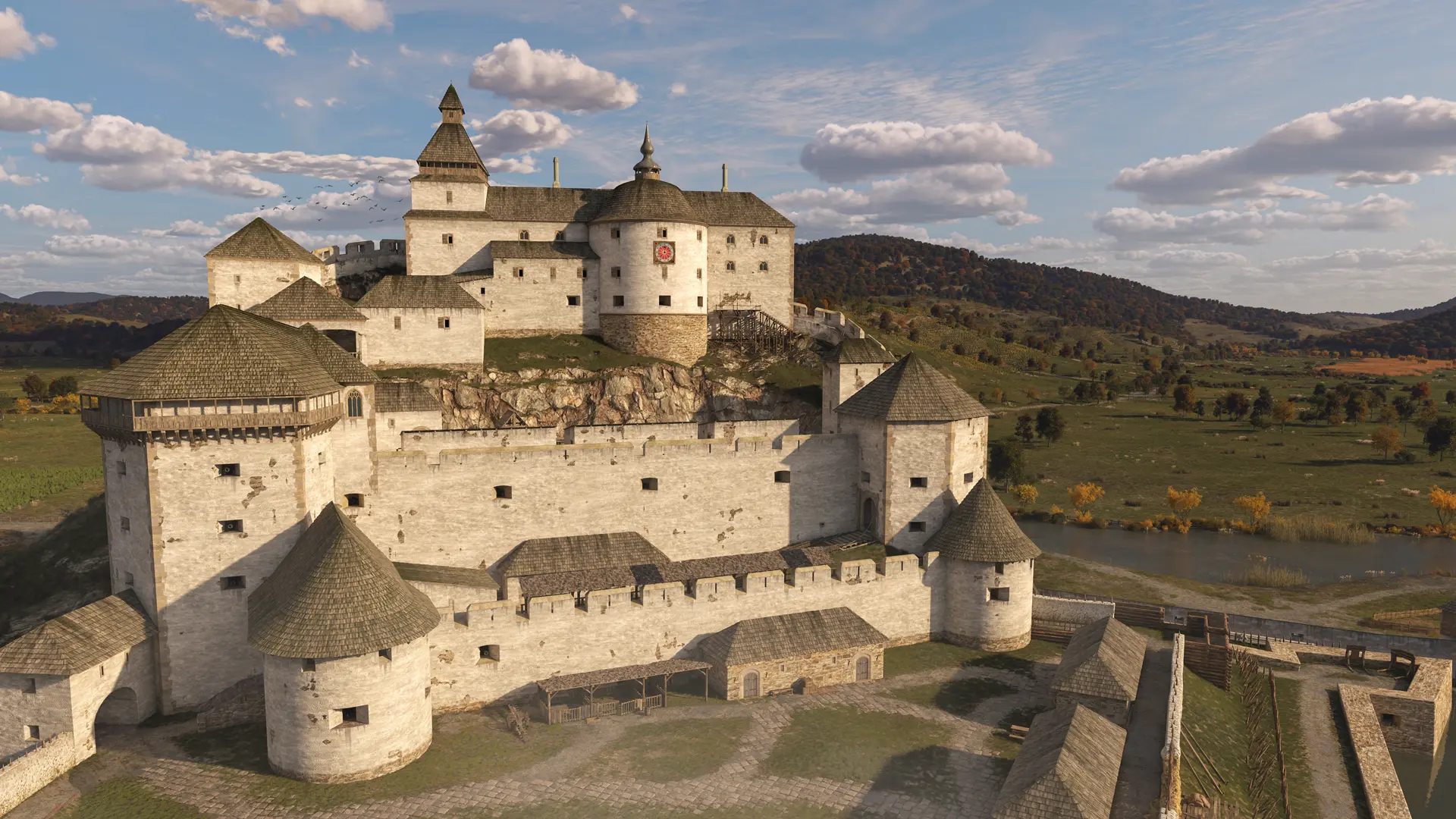
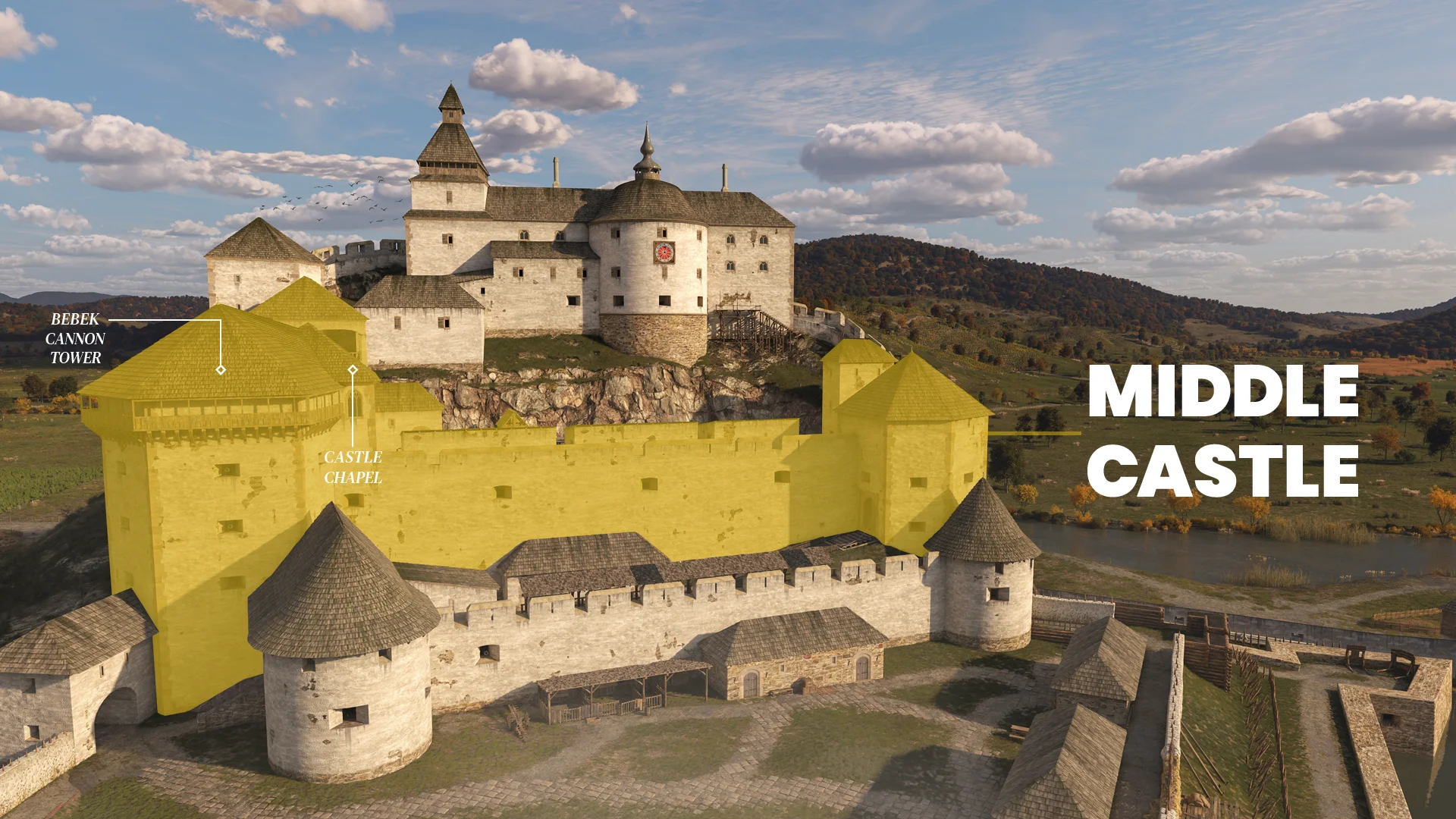
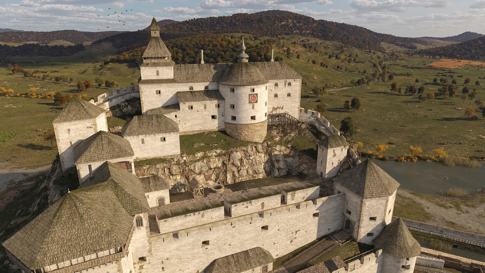
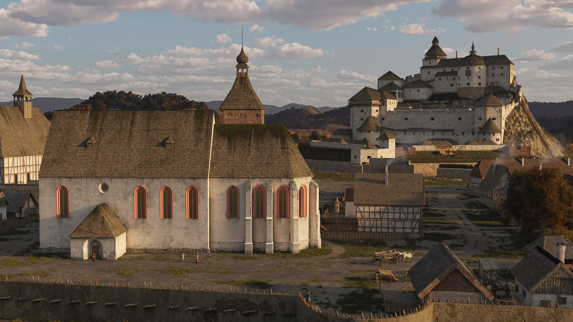
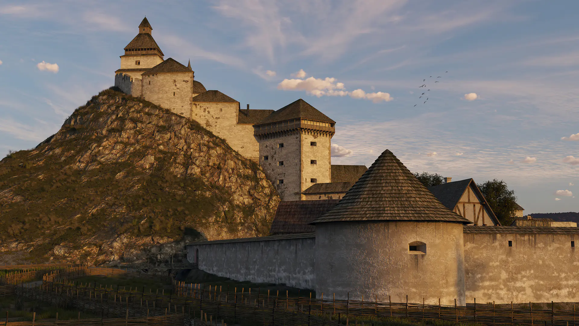
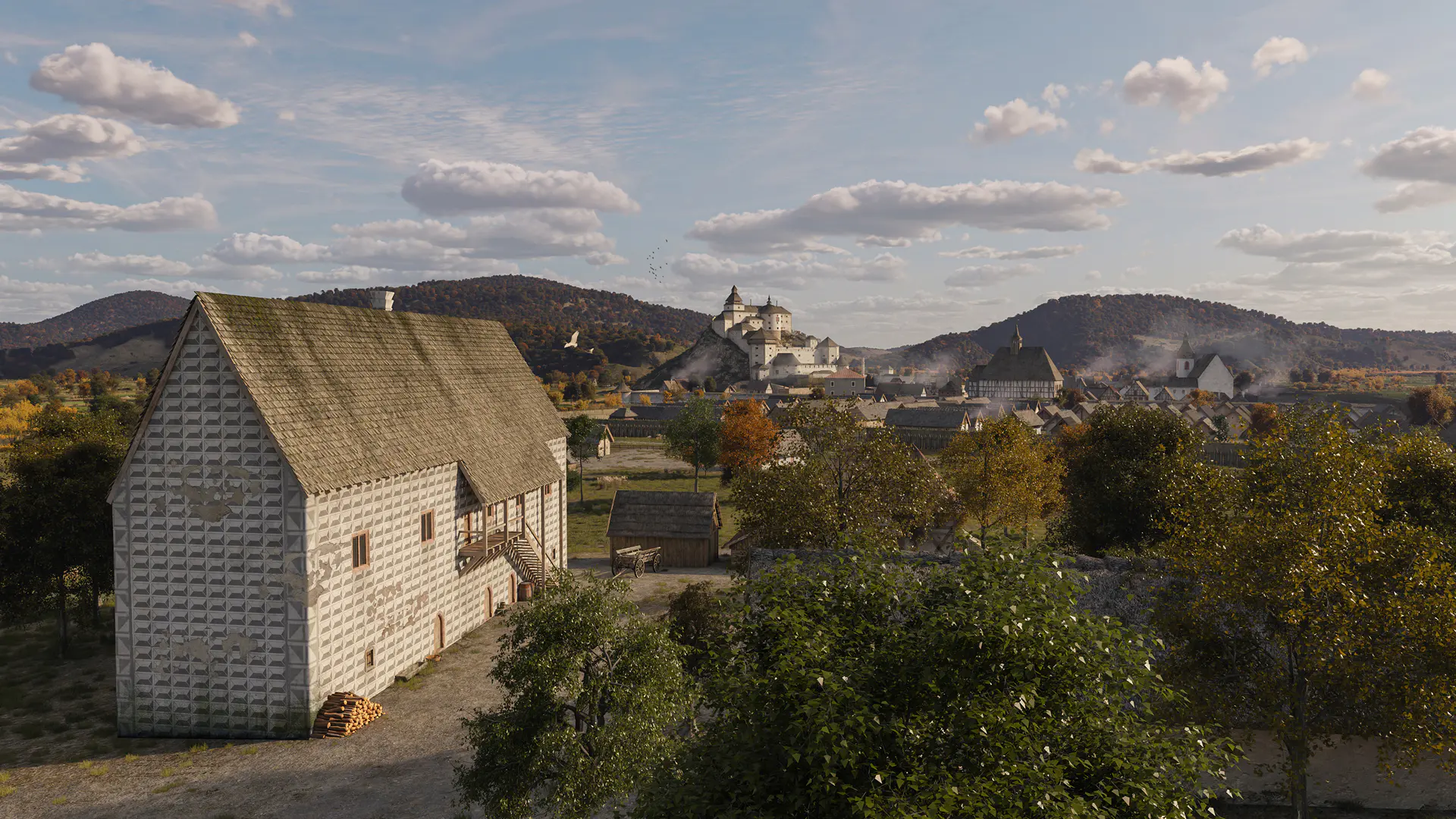
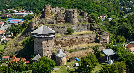
The 17th-century Theoretical Reconstruction of Fülek Castle

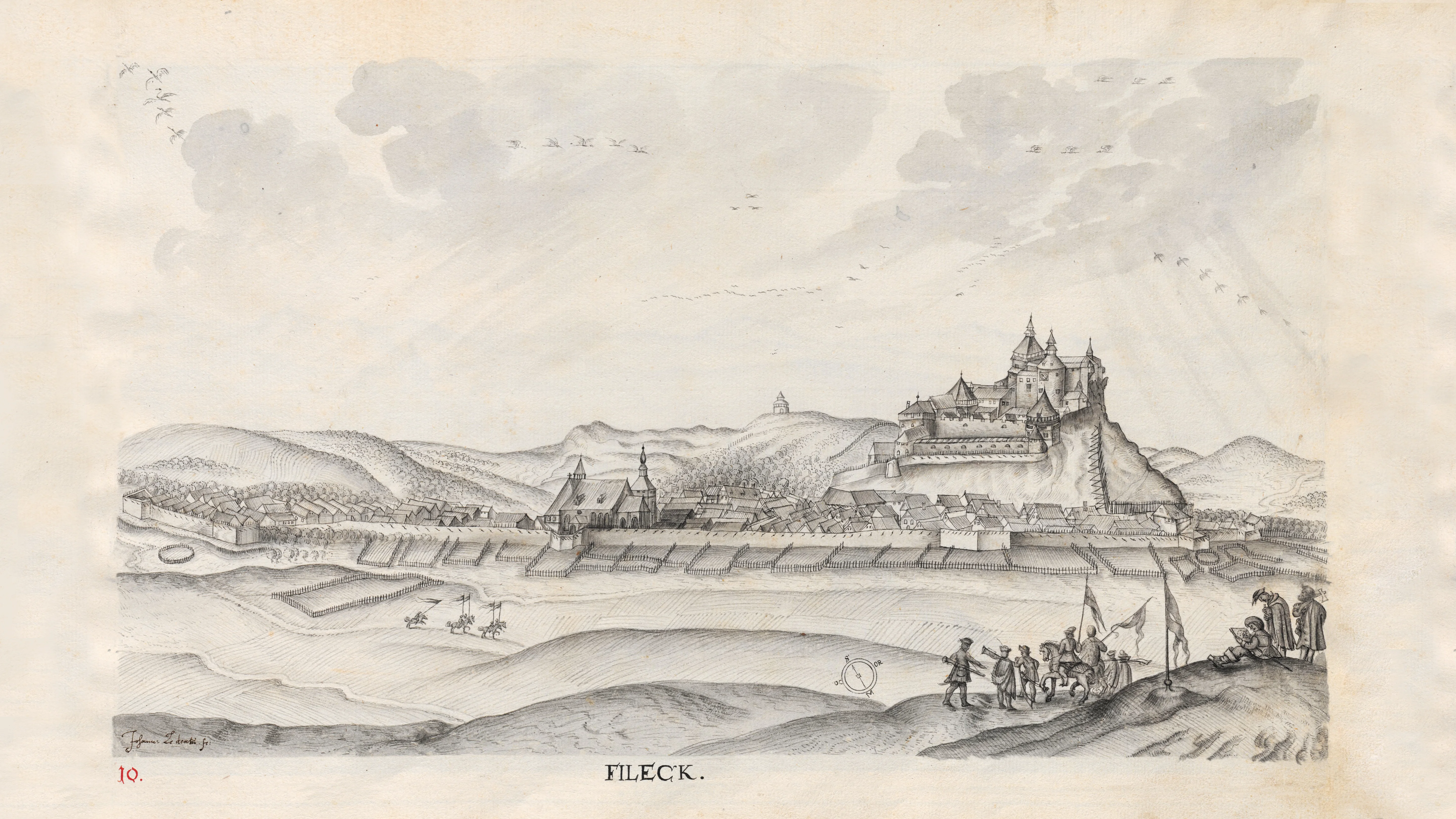
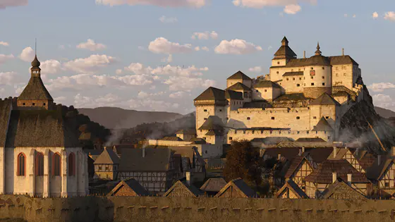
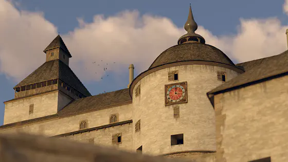
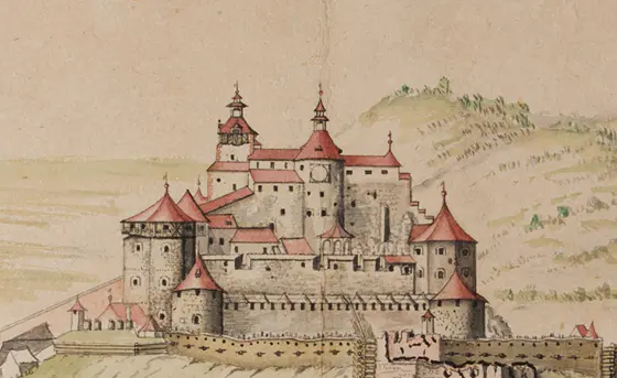
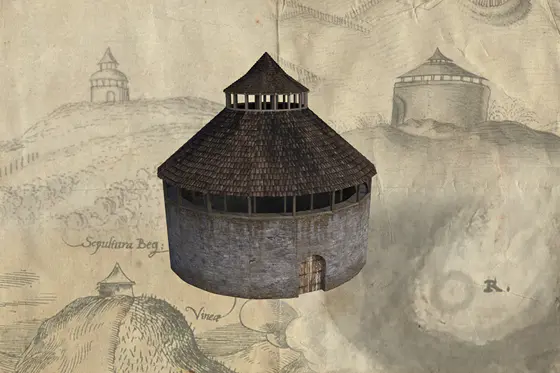
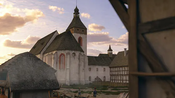
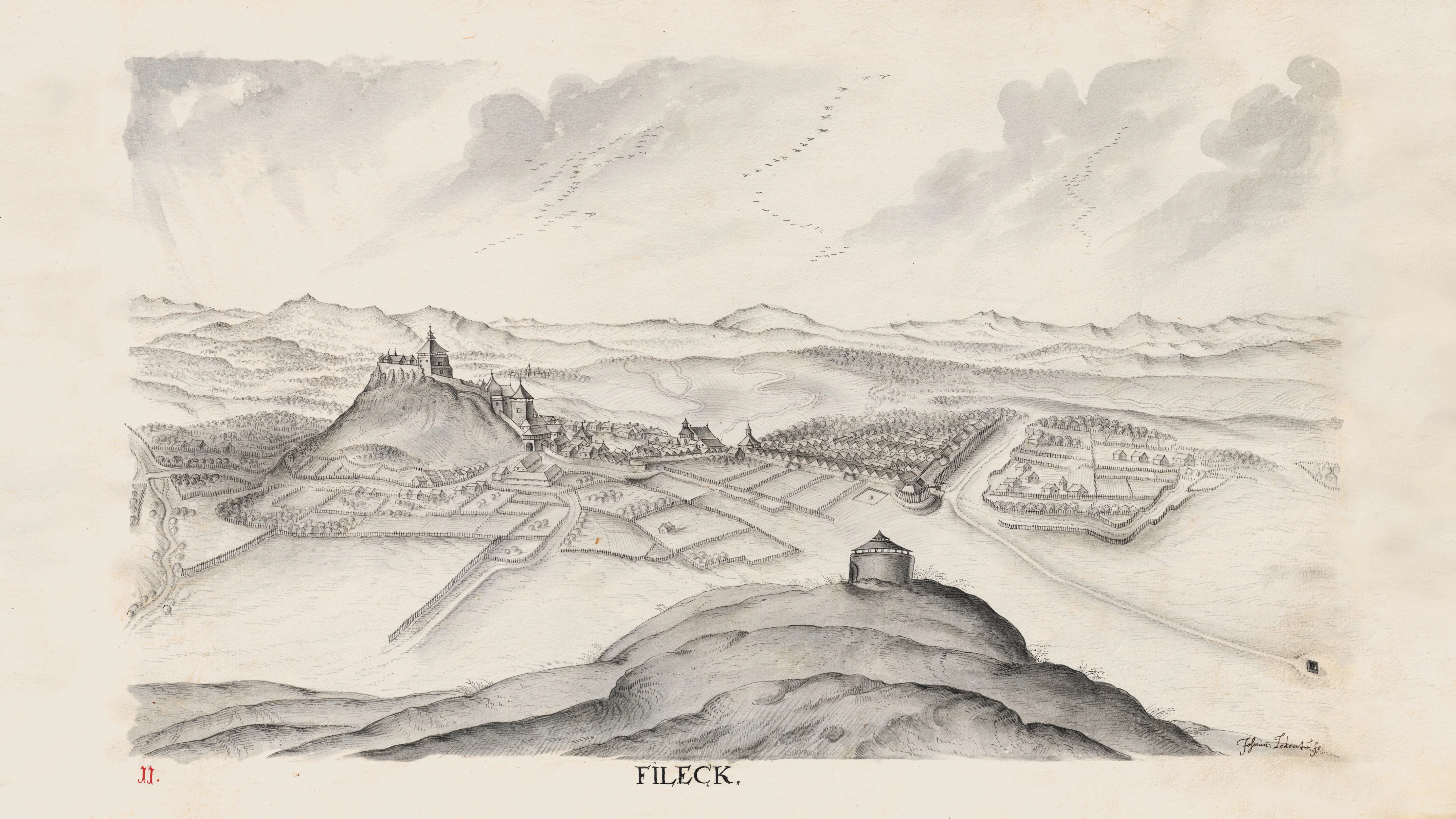
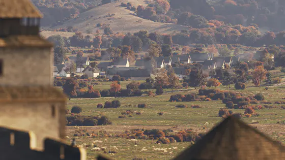
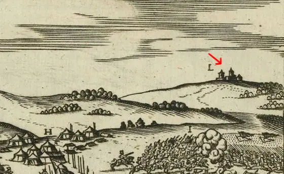
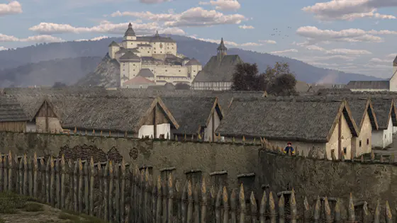
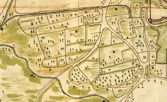
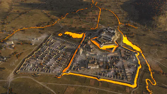
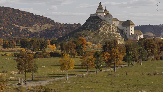
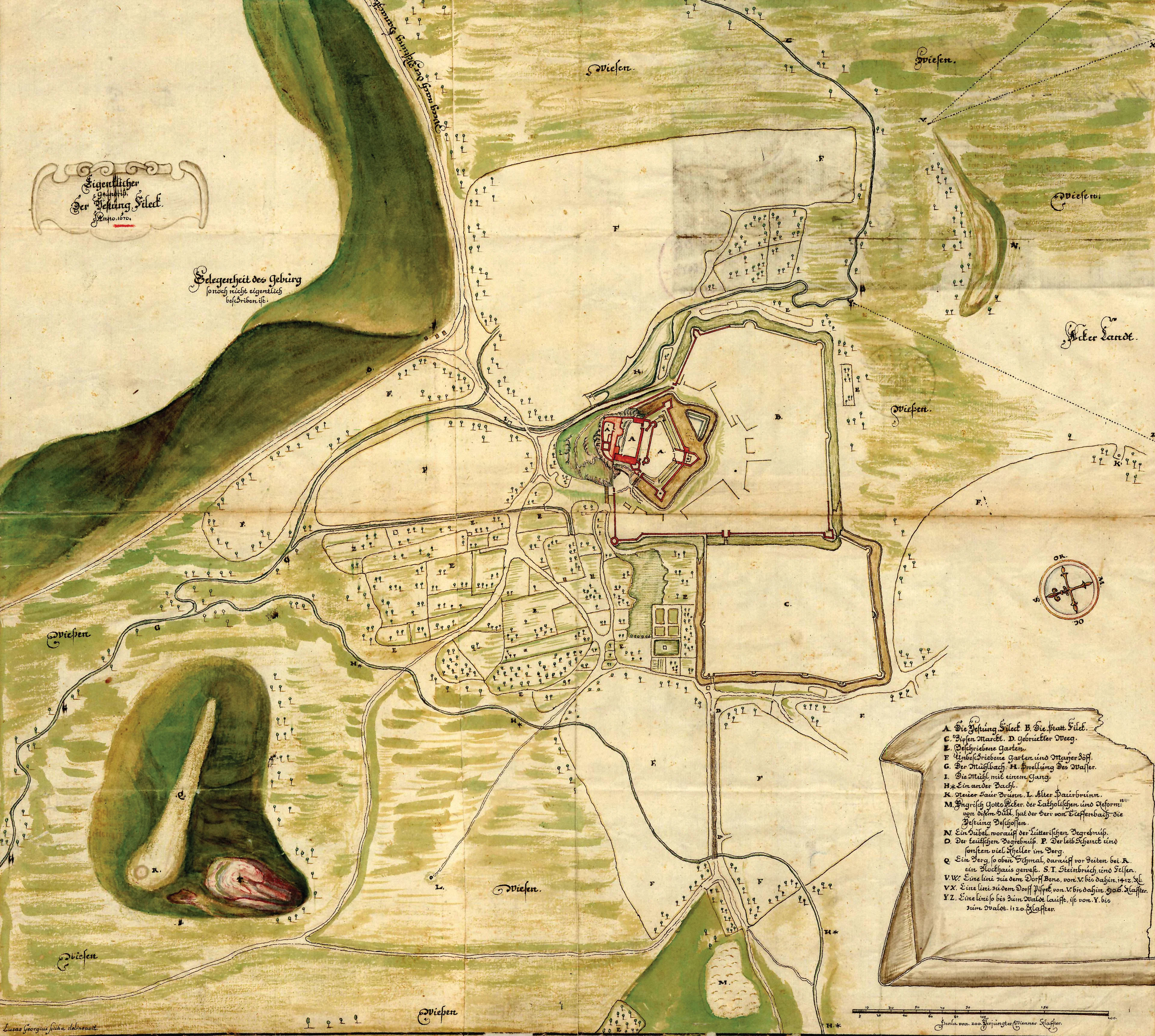
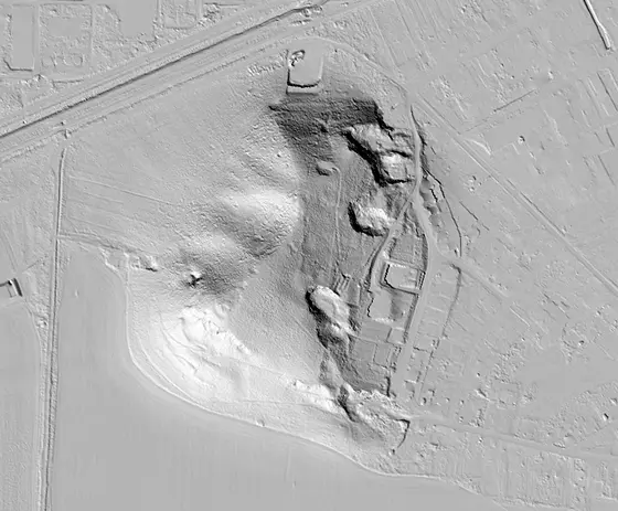
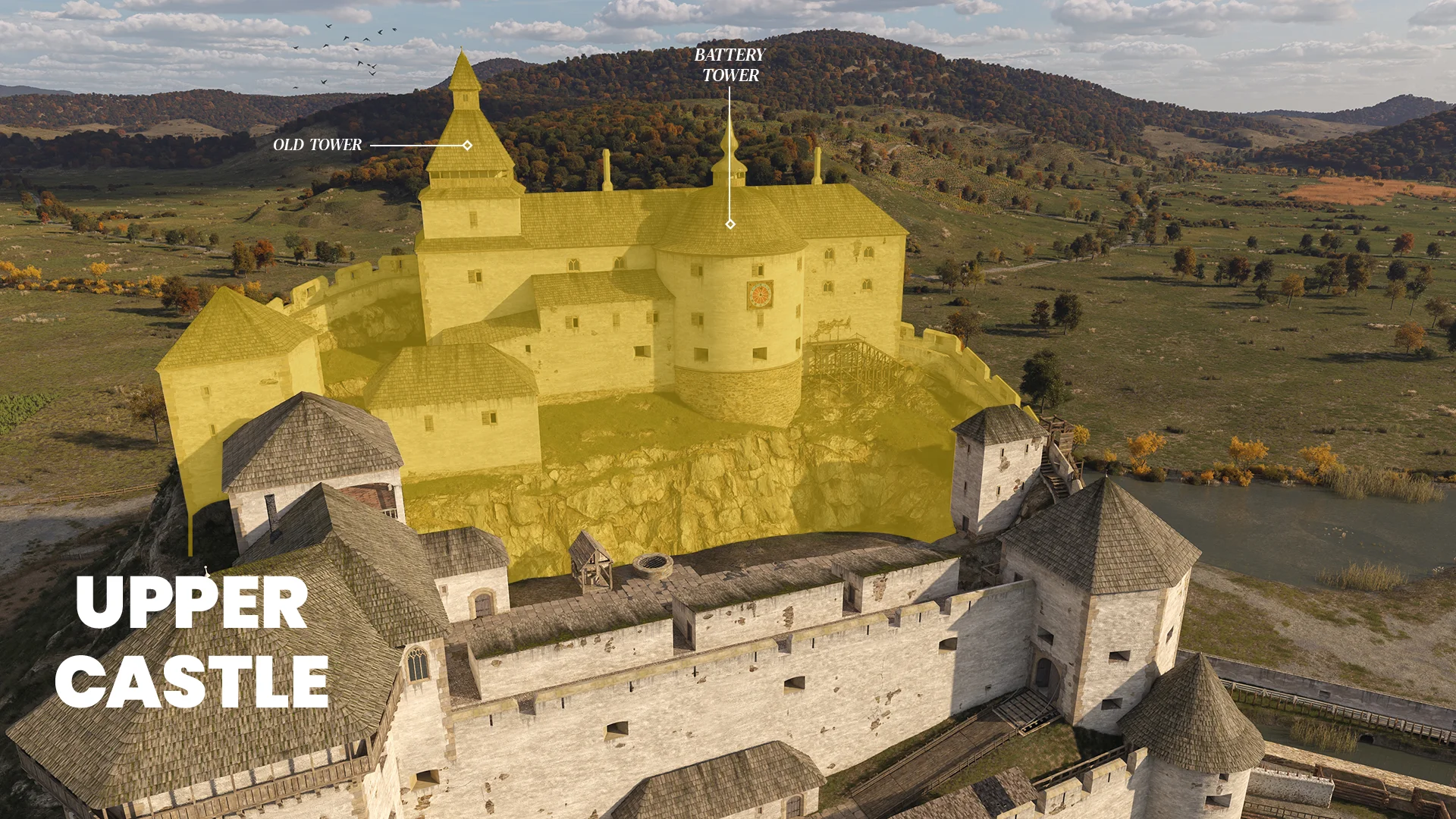
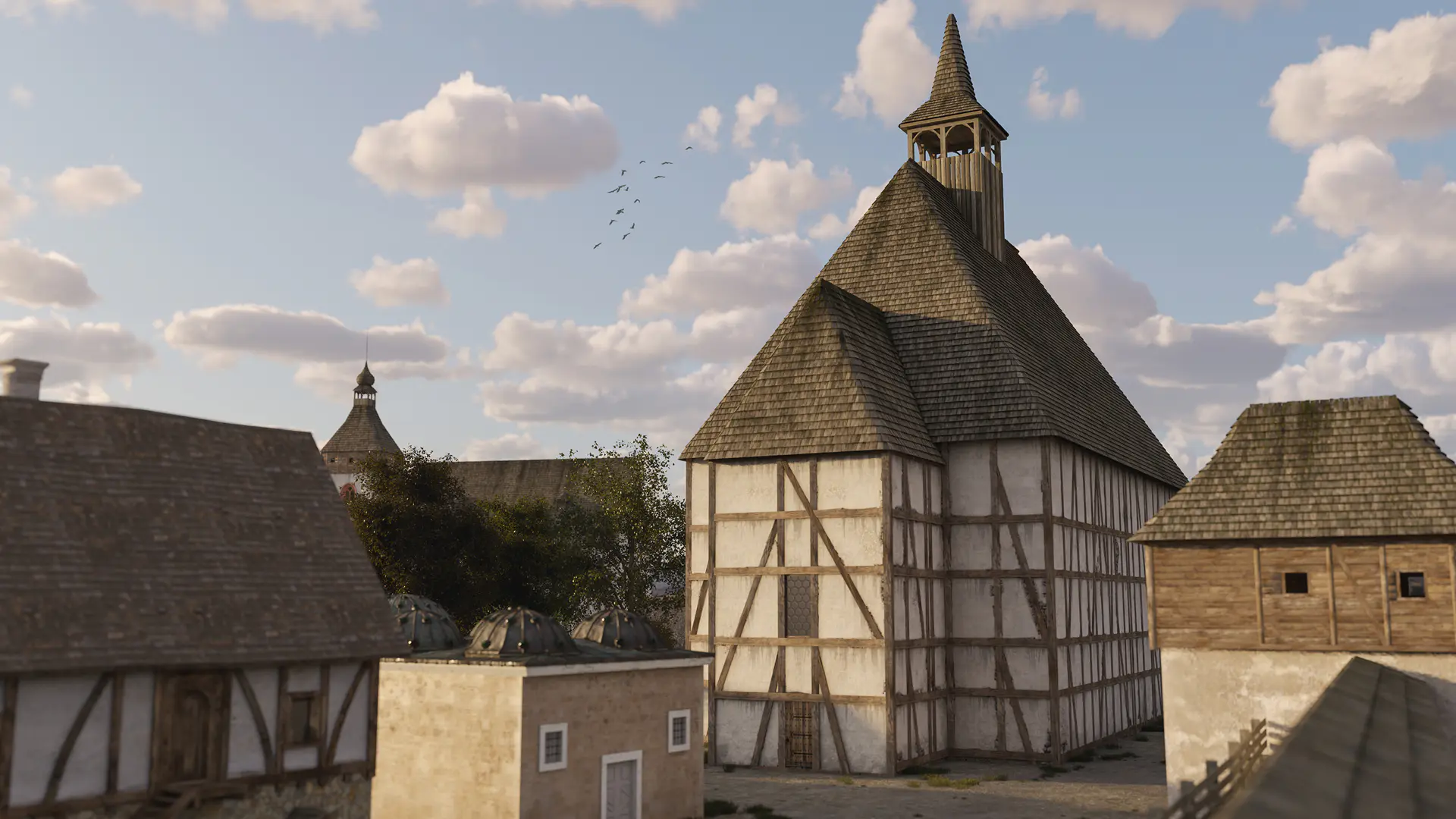
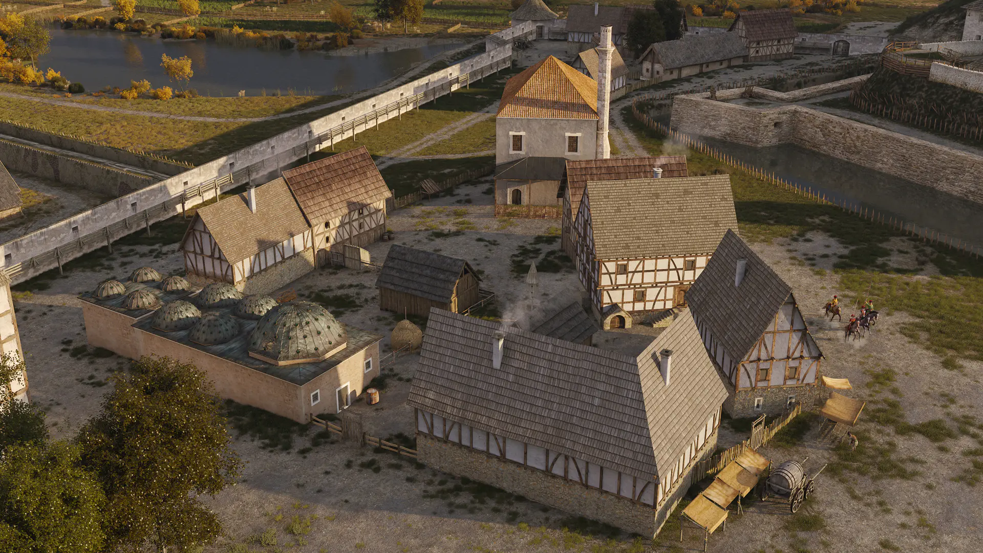
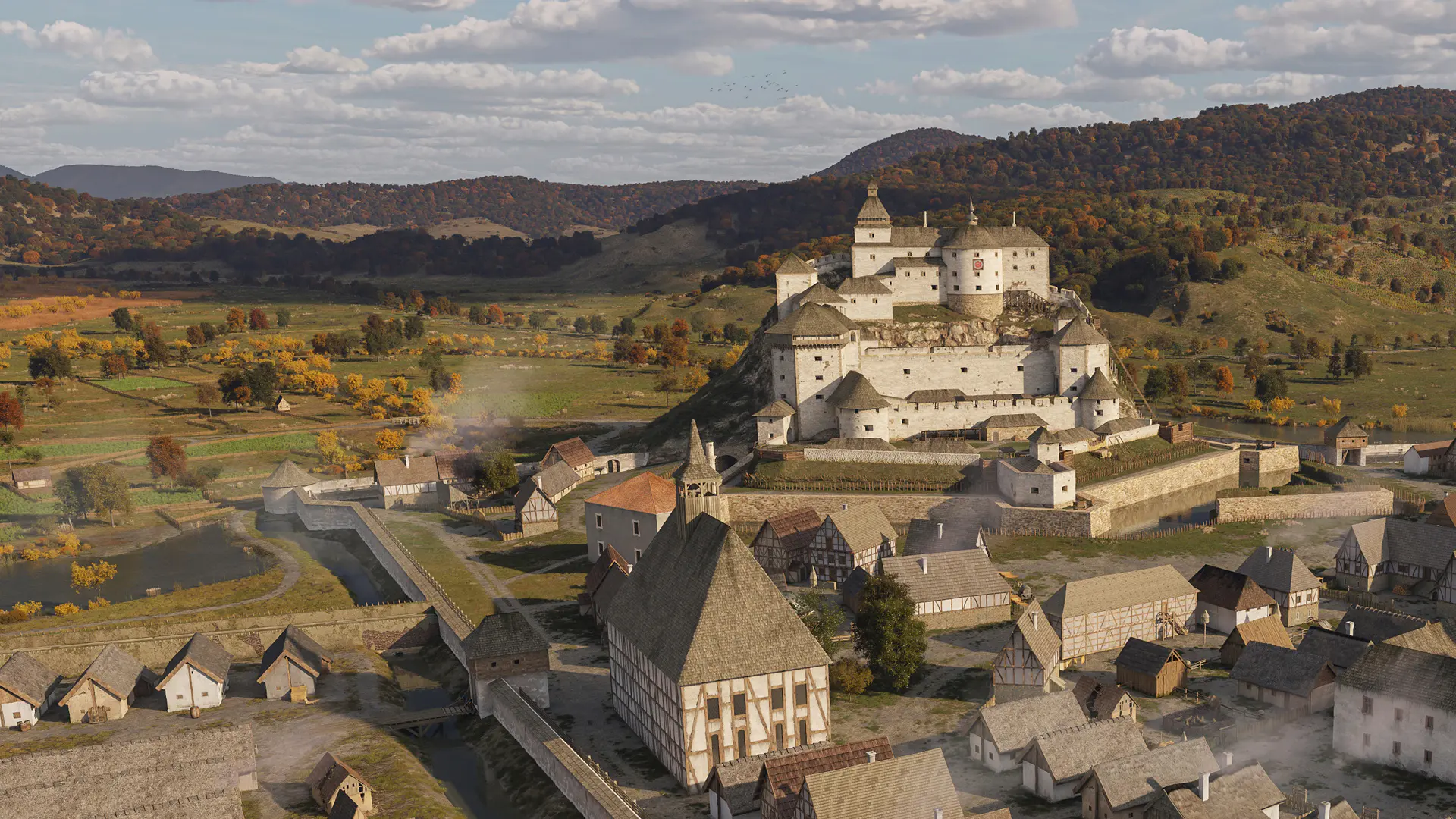
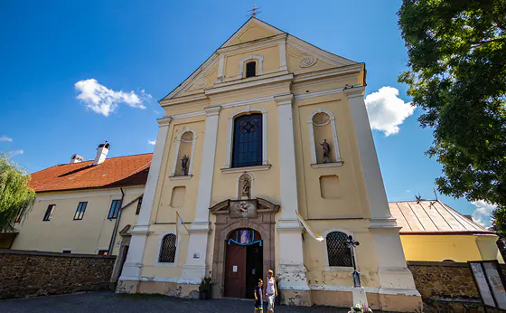
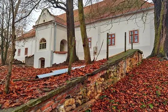
Fülek (present-day Fiľakovo, Slovakia) Castle is situated in the southern region of Slovakia, within the Ipoly River basin, formerly part of Nógrád County. This town, characterised by its Palóc dialect, and located at the foot of the Bükk Mountains along the banks of the Béna Brook, near the main road leading to Somoskőújfalu, couldn’t escape our attention. We were certain that creating a theoretical reconstruction of the landscape would be an exceptionally exciting endeavour, given that there are several detailed depictions of the settlement from the 17th century, including a map from 1670, which revealed numerous intriguing details. These details bring the reconstruction to life and enhance its credibility since the Turks obliterated the entire town in 1682, and thus, little has remained of its former glory. Based on contemporary descriptions and illustrations, we sought to revive the former splendour of te town with the assistance of the archaeologist and art historian, Gergely Buzás. Below, we present how the theoretical reconstruction was developed using these small and intriguing details.

Le Dentu

Le Dentu

Johann Le Dentu, the Viennese court painter and military engineer, provides astonishingly detailed depictions of Fülek around 1640, from both a northern and a southern perspective. The meticulously crafted images reveal some details that precisely correspond to Lucas Georgius Syicka’s 1670 site plan, while also pointing out the changes that transpired in the town over the 30 years between the completion of the two drawings. These illustrations played a crucial role in the reconstruction process, as we had to compare the depicted objects with the extant buildings, archaeological data and geodetic surveys in order to accurately fit them into place.

Image Source: Johann Le Dentu, military engineer and court painter 1639/1640.
@ Ledentu, Iohannes: Confinia regni Hungariae. Wien, 1639. ÖNB Cod. 9622

The Castle of Fülek

Fortunately, several usable depictions of the castle have survived, enabling us to reconstruct its former glory with a high degree of certainty. The Le Dentu drawing provides a comprehensive depiction of the building complex from several angles, exposing the precise building materials and structural elements. By 1670, the castle had undergone some further development; however, it broadly retained the form depicted in the drawing.

Image Source: Virtual theoretical reconstruction - Pazirik LLC.

The Clock Tower

In period depictions, it is evident that the battery tower, currently known as the Clock Tower, housed a clock mechanism.

Image Source: Virtual theoretical reconstruction - Pazirik LLC.

The Clock Tower

Unfortunately, none of the depictions offer sufficient detail of the clock; however, the round clock face appears in multiple instances, allowing us to imagine the appearance of Fülek Castle’s clock based on analogies.

Image Source: Fillek (G I h 3869) - a colourised drawing from 1680.
@ Hungarian Institute and Museum of Military History

Watchtower on Vöröskő

In Le Dentu’s era, a watchtower stood to the north of the castle, situated on a narrow ridge of Vöröskő Hill. Between 1554 and 1593, the castle came under the protectorate of the Ottoman Turkish Empire. The watchtower might have been constructed at this time, as Fülek, the northernmost sanjakbey’s seat of the Ottoman Empire threatening Hungarian mining towns, faced primarily northern Hungarian attacks. The 1670 map only mentions the location of the previously destroyed tower.

Image Source: Virtual theoretical reconstruction - Pazirik LLC.

Church and Monastery

One of the central buildings of the town stretching by the southern foothills of the castle is the Gothic Franciscan church and monastery, built in 1513, on the site of the present-day Roman Catholic Church of the Assumption of the Virgin Mary and monastery. During the Ottoman era, the conquerors converted this structure into a mosque, although it later came back under Christian control once again. Regrettably, it was obliterated in 1682. Count István II Koháry undertook the reconstruction of the building complex in the Baroque architectural style between 1694 and 1727. The layout of the previous Gothic church has been preserved, allowing for theoretical reconstruction.

Image Source: Virtual theoretical reconstruction - Pazirik LLC.

Le Dentu

Le Dentu

Another depiction by Le Dentu depicts the settlement from a different angle, providing invaluable insights. This perspective not only reveals the northern side of the town but also offers a view of the surrounding countryside, presumably from atop Vöröskő Hill, from the watchtower that was present at that time.

Image Source: Johann Le Dentu, military engineer, and court painter, 1639/1640.
@ Ledentu, Iohannes: Confinia regni Hungariae. Wien, 1639. ÖNB Cod. 9622

Villages in the Distance

The drawing captures minute details, such as the village of Fülekpüspöki, situated about 3 km south of the city. Another village, Béna (formerly known as Benna), lies approximately 1.5 km away, concealed by a hill.

Image Source: Virtual theoretical reconstruction - Pazirik LLC.

Somoskő Castle in the Distance

The contours of the terrain visible on the horizon faithfully adhere to real geographical topography, and a discernible structure depicted amidst distant mountains is likely a representation of Somoskő Castle. It is not only the location of the castle that corresponds to that of Somoskő, but is also identified in other vedute with similar perspectives, accompanied by inscriptions confirming the location.

Image Source: Abraham Ortelius - Fülek 1593-as ostroma (The 1593 Siege of Fülek) (detail)
(CONTERFACTVR DER VOESTVNG VILLECK. WIE DIE VON DEN CHRISTEN BELEGERT VND ERÖBERT.)
@ National Széchényi Library (Map Collection, TA 151 arch A-140)

Urban Fortifications

Following the recapture in 1593, immediate efforts were launched to modernise the fortifications of both the castle and the city. The new defensive structures were partially made up of palisades, and only in the 17th century were some of them converted into stone walls. It was during this period that a substantial city wall was constructed, some elements of which had remained visible until the mid-20th century, including the round corner tower that is still in place. The 1670 survey map excellently illustrates the different parts of the defences, showing which sections were smooth, wattle-woven, or clay-coated double rows of posts, and which were reinforced with compacted palisades strengthened by earth fill. The external façade of this is adorned with the dovetail joints of the overhanging beams. The structures built from stone are clearly distinguished in the drawing, featuring embrasures cut in the castle wall, equipped with a rampart walkway.

Image Source: Virtual theoretical reconstruction - Pazirik LLC.

Latorkert (Villain Garden) featuring severed heads

A portion of the moat surrounding the walls contained water, and on the other side of the moat was a so-called “villain garden,” an area with stakes interwoven with wattle. Noteworthy are the stakes with severed human heads placed in the outer suburbs near the drawbridge gate. It was a prevalent custom of the time to behead executed enemies, abettors and traitors, displaying their heads as a deterrent at entrances. This detail is observable in numerous vedute.

Image Source: Virtual theoretical reconstruction - Pazirik LLC.

Gardens and Pastures

The city was surrounded by extensive gardens, as illustrated in the 1670 map, which intricately depicts their fences and plot boundaries—specifically those gardens that were officially entered into the land registry. The grassy, marshy meadows and pastures are consistently marked, as well as the hillside vineyards dotted with cellars.

Image source: Lucas Georgius Szicka - Colour photocopy of the map “Der Festung Fileck” (G I h 3868) from 1670.
@ Military History Institute and Museum

Hydrography

An essential element in the castle’s defence was the water supply system, continuously improved and maintained since the 13th century. This system consisted of rock-carved drainage channels, cisterns and a well. Beyond the city walls, a fishpond is visible, marked in several depictions. The waters of the streams were dammed, directed into mill races, and clearly depicted on the map, showing which parts of the city moat had water and where it was dry.

Image Source: Virtual theoretical reconstruction - Pazirik LLC.

Acidic Spring Wells

The 1670 map illustrates two acidic spring wells, namely the old and the new acidic spring well (in German, Alter Saur Brunn and Neuer Saur Brunn). The old well is also depicted in Le Dentu’s drawing, located northeast of the city accessible via a separate dirt road. Acidulous mineral water, known as “borvíz” in Transylvanian terms and “csevice” in the local dialect, is a natural spring water with a sour taste, particularly due to its carbonic acid content. It was believed to have healing properties against heart diseases, stomach, liver and intestinal disorders.

Image Source: Virtual theoretical reconstruction - Pazirik LLC.

Anno · 1670

Le Dentu

Legend of the 1670 Map

A. Fülek Castle       B. City of Fülek
C. District of the Zipser Germans    D. Dorongút (Log road)
E. Gardens entered into the land registry
F. Gardens and households not entered into the land registry
G. Mill race       H. Water balancer
I. Single-blade mill
H* Another brook
K. New acidic spring well       L. Old acidic spring well
M. Catholic and Protestant Cemetery.
Mr Tiefenbach fired at the castle from this hill.
N. A hill in front of the Lutheran cemetery
O. German cemetery       P. Vineyards and cellars on the hill
Q. A hill with a narrow ridge,       R. formerly with
a guardhouse.       S.T. Quarry and rocks
VW.  A line to the village of Benna, from V to here 1412 Klafter
(Viennese klafter, unit of length)
VX. A line to the village of Fülek Püspöki, from V to here 906 Klafter
(1 Viennese Klafter = 1.8965 m)
YZ. A line running along the trees, from Y
to the trees, 1120 Klafter

Vöröskő Hill

According to the legend of the 1670 map, at the end of the ridge of Vöröskő Hill, there used to be a watchtower, its remnants marked with a circular spot (R). Next to it, you can see the rock, painted red (T), and the quarry (S). Almost certainly, the hill derives its name from the colour of the rock that makes it up. As the image, taken by using LiDAR (Light Detection and Ranging; a remote sensing method) scanning technology clearly demonstrates, stones have been extracted here for centuries as a building material.

Image Source: LIDAR Survey - Geodetic and Cartographic Institute Bratislava (GKÚ), Chlumeckého 4, Bratislava

Log road

A timber road (D) leading westward from the entrance of the Saxon suburb is not only depicted clearly on the map but also indicated in the legend. Such roads, constructed using logs, were built in places that periodically became muddy and swampy. This design ensured that heavy carts wouldn’t get stuck in the mud, allowing them to approach the city on a solid path.

Image Source: Virtual theoretical reconstruction - Pazirik LLC.

Fishpond and Ornamental Garden

The fishpond in Fülek is not only featured on this map, but appears in nearly every surviving depiction. Along its shores, we see a meticulously arranged ornamental garden with a rectangular pool. In the centre, we can see an unidentified object—perhaps a fountain or a small island. The gardens may have originated from the Ottoman era, as it was customary for the Turks to establish such features; however, we lack specific data to confirm this.

Image Source: Virtual theoretical reconstruction - Pazirik LLC.

Mill and Swollen Stream

The map illustrates a single-blade water mill, built adjacent to the millrace. At one point, the water of the stream appears to have been intentionally swollen. This could have been essential both for operating the mill and for swiftly filling the moats with water when the situation demanded.

Image Source: Virtual theoretical reconstruction - Pazirik LLC.
Alsó vár Alsó vár 2

Construction of Fülek Castle

The construction of Fülek Castle took place during the first part of the 13th century on a steep volcanic cone, reaching a height of 65 metres on its northern side. The fortification is divided into three parts: lower, middle and upper castle. Additionally, the settlement situated by the foot of the hill forms two enclosed areas contained by walls.

Lower Castle

The artwork portrays the lower castle in its 17th-century state, on a low hill overlooking the plain. It was a modern bastion fort (trace italienne), protected by a deep moat. Outbuildings, as well as storehouses and stables were located in its bailey. Access to the inner curtain wall was provided through stone stairs from the lower castle, guarded by a horseshoe-shaped bastion. Another, smaller bastion blocked the path of the enemy from the direction of the lower castle. The outer curtain wall terminates at the three-storey Perényi Gatehouse, constructed during the Bebek expansion and later named as such. Located in front of it is a trou-de-loup (French for “wolf pit;” a pit designed to trap enemies) with a drawbridge, allowing water from an upper-level cistern to be released, thus impeding the progress of attackers.

Ascending the stairs through the Perényi Gatehouse, we arrive at the courtyard of the middle castle. On the right-hand side, visitors can see the ruins of the house that used to accommodate the winch. This structure was used to hoist heavy crates and barrels through a chute carved into the rock, employing winches.

According to historical records, the task of cleaning Fülek Castle was assigned to a Saracen slave. The slave would remove the gathered waste through a hatch, which was sealed with an iron board, located in the eastern wall of the middle castle.

He noticed a narrow rock ledge beneath the hatch that would have allowed a few people to stand and infiltrate the castle through the opening.

He communicated his discovery by a ransomed Turkish companion to Kara Hamza, the Ottoman bey of Szécsény, who, along with 400 selected warriors, set out to capture the castle. On the night of 4 September, the Turkish troops from Szécsény scaled the walls of Fülek’s middle castle, where the Saracen slave awaited them. Entering through the opening, they seized the towers and opened the gate.

As Captain Pál Jánossy was absent from the castle the day before, much of the garrison was revelling in drunken merriment and later fell into a deep sleep. The startled defenders fought desperately, but the overwhelming force of the army of Tojgun, Pasha of Buda, swiftly occupied the strategically significant Fülek Castle.

Ottoman rule:

1554 - 1593

Középső vár Középső vár kiemelés Felső vár Felső vár kiemelés Kiemelt épületek Török kori épületek

The Middle Castle

Three vaulted casemates were constructed in the walls of the middle castle. In the heart of the courtyard, a deep cistern and a well reaching the groundwater level were carved into the rock. Adjacent to it, visitors can observe the watch post of the guard responsible for monitoring the drinking water. Slightly further away, a prison was carved into the rock. Soaring above the southwestern corner is the Bebek Cannon Tower, erected in 1551 by Ferenc Bebek of Pelsőc. The four-storey tower, forming a unique transition between the tower and the bastion, still stands today. The castle chapel was located to the north of the tower.

The Upper Castle

A series of steep stairs carved into the rock extend up to the oldest section from here to the upper castle. By making a right turn at the gatehouse, one can ascend the stairs that lead to the semi-circular battery tower. There used to be a palace wing with casemates, located behind it. In the small inner bailey, positioned directly above a grain pit measuring 5x5 metres, there was a dry mill specifically designed for the purpose of grinding grain to sustain the guards. The old tower, erected during the early stages, stood tall in the western section of the castle.

Historic Buildings

In the mid-17th century, two churches stood in the city, clearly visible in Le Dentu’s illustrations. One of them is the 16th-century Franciscan monastery and parish church, which we have previously discussed. The Lutheran church, located northwest of the aforementioned building, is documented only through the illustrations and historical accounts of Le Dentu. From the available evidence, it was likely a timber-framed structure with a north-south orientation, equipped with a hussar tower. Le Dentu’s paintings clearly depict several multi-storey structures in the city, including notable historical landmarks like the Lutheran Grammar School. We have symbolically placed these edifices in the cityscape based on the illustrations.

Architectural Constructions from the Ottoman era

Only a small number of buildings from the Ottoman era remained in the city during the 17th century. Some of the former mosques and baths have been included in the reconstruction, although their original locations and appearance remain unknown.

What Remains

A füleki vár Ferences kolostor Kerek bástya Koháry-kúria

The Castle of Fülek

The southern side of the castle today

Following the devastating destruction in 1682, the once glorious era of Fülek Castle came to a permanent end, and its walls have never been rebuilt. During his visit to Fülek, our esteemed poet Sándor Petőfi bitterly recorded that the stone walls soaked in the blood of heroes were dismantled by the local population, and repurposed them as building material. The castle ruins were first explored in the 1940s, and since the 1970s, efforts have been underway to gradually restore its remnants.

Catholic Church and Franciscan Monastery

The western façade of the church

The Gothic church and monastery, constructed in 1513, were destroyed in 1682. Nevertheless, under the guidance of Lord Chief Justice István Koháry, a restoration endeavour was undertaken from 1694 to 1727 in the Baroque architectural style, using the original foundations. The façade underwent modifications between 1725 and 1728. The building had its most recent restoration in 2012.

The Circular Bastion of the City Wall

The western side of the bastion

During the latter part of the 17th century, a segment of the city walls underwent renovation and transformed into a solid stone wall. Although not depicted in the Le Dentu painting, by 1670, this circular bastion had already been constructed and is now the sole remaining vestige of the previous city fortifications.

Koháry Manor

Regrettably, the 16th-century Báthory Manor has not been portrayed; nevertheless, records indicate that Koháry Manor, still standing, was built in the early 18th century in the Baroque architectural style, on the foundations of the former Báthory Manor.

Image Source: The Enchanting Revival of the Fülek Koháry Mansion Part 3
@szmcsmedia


Project Concept
Pazirik LLC. - Zoltán RÓNOKI, András BALOGH
Illustrator
Gábor EPERJESI
Scientific Expert
Gergely BUZÁS
Graphic Designer
Rebeka KÖVES
Synopsis, Screenplay
András BALOGH
English Translation
Szilvia TORMA
Script
Balázs SZAKONYI, Szabolcs VARGA
Software Developer
Zoltán RÓNOKI
3D Modellers
Gábor MENYHÁRT, Zsolt MIHÁLYI, Bence SZABÓ, Balázs SZAKONYI
Photos
Tamás GÁL, Bálint KATONA
3D Texturing
Zsolt MIHÁLYI, Balázs SZAKONYI
Aerial Photography
Tamás GÁL, Bálint KATONA
Landscape Reconstruction
Zsolt MIHÁLYI
3D Camera
Bálint KATONA, Zsolt MIHÁLYI
Historical Landscape, GIS Specialist
Norbert SANDÓ
Financial Manager
Zsuzsanna TÓTH

The historical reconstruction is based on the earlier theoretical reconstruction model of Zsolt Mihályi.

Pazirik LLC.

2023